Monday, February 06, 2006
Too tall and too dense? Atlantic Yards, Downtown Brooklyn, and the elusive FAR
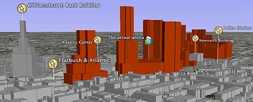 What's the appropriate height and density for the Atlantic Yards project or, for that matter, any other project built on the Metropolitan Transportation Authority's Vanderbilt Yard and environs? There are no rules, since there's been no rezoning for the Atlantic Yards project (despite what the New York Times said and has yet to correct), and the state can override zoning. (Map is from Jon Keegan.)
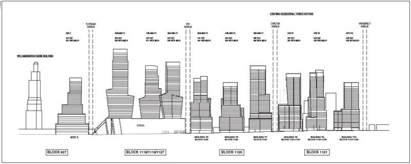 Density involves Floor Area Ratio (FAR), which the city defines as "the total floor area on a zoning lot divided by the lot area of that zoning lot. For example, a building containing 20,000 square feet of floor area on a zoning lot of 10,000 square feet has a floor area ratio of 2.0." Architect Jonathan Cohn did the math and calculated a proposed FAR (roughly: building area divided by site area) of 9.5. (That would include 11 buildings over 400 feet.) As I note below, Forest City Ratner VP Jim Stuckey recently said that the FAR would be 8 to 8.5.
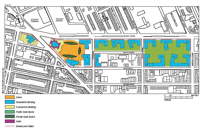
 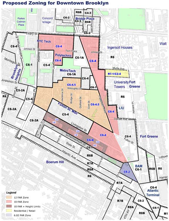 The figure reaches 11 if the streets taken by the project are subtracted, and perhaps tops 12 if the low-rise arena is subtracted. That's comparable to the plans at the World Trade Center site and, more relevantly, blocks at the core of the Downtown Brooklyn rezoning. See the tan blocks in the center marked C6-4.5. Note also that the Atlantic Terminal site (mall/office building), at the southeast edge of the map at right, is also at 10 FAR (C6-4). Note that the Atlantic Terminal mall is in the northwest corner of the map two paragraphs below portraying the Atlantic Yards site plan.
 But only part of the rezoned Downtown Brooklyn has an FAR that reaches 12, and Downtown Brooklyn is not a low-rise residential district. Another comparison might be the extensive rezoning of Williamsburg and Greenpoint, where a recent rezoning proposed waterfront development parcels with districts of 2.43 FAR and 6.02 FAR to produce an FAR of 4.3, which itself is greater than the neighborhoods to the south, east, and north of the Atlantic Yards site.
Downtown Brooklyn or Prospect Heights?
 That raises the question: is the Atlantic Yards site more like dense Downtown Brooklyn, or is it in fact in less-dense Prospect Heights? City officials and Forest City Ratner often describe it as Downtown Brooklyn--the original FCR press release on 12/10/03 stated: Frank Gehry, internationally acclaimed architect, unveils vision for world-class basketball arena and mixed-use complex for downtown Brooklyn. But downtown Brooklyn has historically not crossed Atlantic Avenue, and barely crossed Flatbush Avenue, if at all. The Department of City Planning describes it as "[g]enerally bounded by Tillary Street to the north, Ashland Place to the east, Atlantic Center and Schermerhorn Street to the south, and Court Street to the west." The Atlantic Center mall is north of Atlantic Avenue, but east of Flatbush, as is the Atlantic Terminal mall.
 Also note that one triangle of land, at the southeast tip of the proposed Downtown Brooklyn rezoning, was subtracted from the rezoning because it would be the northwest tip of the Atlantic Yards project. This segment is arguably the part of the Atlantic Yards project that might be considered Downtown Brooklyn.
 An authoritative book, The Neighborhoods of Brooklyn, describes the Atlantic Center Mall as being in Fort Greene and says that the western border of Prospect Heights is Flatbush Avenue and the northern border Atlantic Avenue. And the New York Times, in a 12/18/05 Real Estate section profile of Prospect Heights, mapped out the neighborhood in the graphic at right.
Forest City Ratner VP Jim Stuckey, at an 11/22/05 presentation before the American Institute of Architects, described the density as 8 to 8.5 FAR. "The overall density, across this entire project, to be built to exactly what’s proposed today, would be roughly eight to an eight and a half FAR," he said, according to a tape of the meeting. "Which while it looks to people thinking of a large amount of space, in fact, in the adjacent Downtown Brooklyn plan, which was approved not too long ago, the density in that plan ranged from an 8 to a 10 FAR....The density of this project is really not all that different than what recently went through the public approval process."
But Downtown Brooklyn is not Prospect Heights, a mostly residential district which borders low-rise residential districts. And it's not clear whether Stuckey was describing the average density in the Downtown Brooklyn plan. The rezoning actually reaches an FAR of 12 on some blocks, but other blocks retain densities of 2, 4, and 6 FAR.
 I asked Brad Lander of the Pratt Center for Community Development about the right comparision for the Atlantic Yards site. He observed, "It is very difficult to say. Of course, people who live immediately adjacent to the site have a reasonable point that they think the relevant comparison is their own, immediately adjacent blocks (which have average FAR of 2.5-4). Essentially, the Brooklyn Atlantic Yards plan would extend downtown Brooklyn much further to the east than most people would say it currently goes." (The photo above, at the corner of Dean Street and Sixth Avenue, contains buildings that would be within the project footprint and thus demolished.)
Indeed, is Vanderbilt Avenue, the eastern border of the Atlantic Yards footprint, part of Downtown Brooklyn? Look at the map above. There is an argument, however, for increased density in the northwest tip of the Atlantic Yards footprint, where the Williamsburg Savings Bank is 512 feet, as well as along the northern border, the south side of the wide Atlantic Avenue, which has some tall buildings, 15-30 stories, along its north side, including the Bank of New York tower at the Atlantic Terminal mall.
What density suggests
An Environmental Impact Statement (EIS) from the Empire State Development Corporation is expected in the next few months. Lander observed, "One challenge is the FAR is really relevant for two totally different things: context/urban design, and infrastructure. Context/urban design is really a matter of taste: what you like, want to look at, and want to live near, so it is difficult to give an objective basis for comparison or analysis. Infrastructure is more objective: how much traffic, transit, weight, energy, water, waste, schoolkids, etc. can an area handle and still function well. This is why a genuine EIS, with good scrutiny and real analysis, alternatives review, mitigation, etc. is so important."
# posted by Norman Oder @ 6:40 AM 
![]()